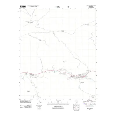
2011 Map of Mescalero
USGS Topo · Published 2011About this map
Mescalero and Bent serve as the primary hubs in this high-altitude landscape where the Sacramento Mountains meet the waters of Tularosa Creek. The area is deeply marked by its institutional and industrial history, evidenced by the presence of Saint Josephs Mission and the historic Blazers Mill. Genealogists will find significant value in the documentation of local burial grounds, including the Mescalero Indian Cemetery, Walters Cemetery, and Blazers Cemetery, which provide a clear link to the families of this region.
Find a feature on this map
38 named features on this map. Tap any name to fly to it.
Don’t see what you’re looking for? This feature index may not catch every label — zoom into the map to look around manually.
Map Details
Editions of this 2011 Mescalero Map
This is the sole edition of this map. No revisions or reprints were ever made.
Other maps of this area

1950 · Sierra Blanca Peak
USGS Topo · 1:62,500

1950 · Mescalero
USGS Topo · 1:62,500

1955 · Roswell
USGS Topo · 1:250,000

1958 · Roswell
USGS Topo · 1:250,000

1962 · Roswell
USGS Topo · 1:250,000

1963 · Ruidoso
USGS Topo · 1:24,000

1963 · Firman Canyon
USGS Topo · 1:24,000

1963 · Apache Summit
USGS Topo · 1:24,000
1981 · Golondrina Draw
USGS Topo · 1:24,000
1981 · Cat Mountain
USGS Topo · 1:24,000