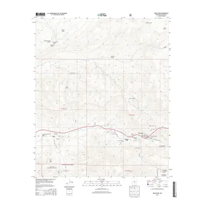
2013 Map of Mescalero
USGS Topo · Published 2013About this map
Tularosa Cr carves through this high-altitude landscape of the Sacramento Mountains, defining the orientation of settlements and transportation routes. In the eastern portion of the survey, the community of Mescalero serves as a focal point, anchored by Saint Josephs Mission and the nearby Mescalero Indian Cem. The map provides a detailed view of the rugged canyon system north of the settlement, including Soldier Canyon and Mardem Canyon, which lead toward the heights of Sierra Blanca. To the west, the village of Bent sits near the confluence of several drainages, marked by its local post office and the Walters Cem. Historical industrial footprints are visible at Blazers Mill, while the surrounding Lincoln National Forest encompasses prominent landmarks such as Lion Peak. The network of springs, including Church Spring and Telles Spring, illustrates the critical importance of water sources in this mountainous New Mexico terrain.
Find a feature on this map
55 named features on this map. Tap any name to fly to it.
Don’t see what you’re looking for? This feature index may not catch every label — zoom into the map to look around manually.
Map Details
Editions of this 2013 Mescalero Map
This is the sole edition of this map. No revisions or reprints were ever made.
Other maps of this area

1950 · Sierra Blanca Peak
USGS Topo · 1:62,500

1950 · Mescalero
USGS Topo · 1:62,500

1955 · Roswell
USGS Topo · 1:250,000

1958 · Roswell
USGS Topo · 1:250,000

1962 · Roswell
USGS Topo · 1:250,000

1963 · Ruidoso
USGS Topo · 1:24,000

1963 · Firman Canyon
USGS Topo · 1:24,000

1963 · Apache Summit
USGS Topo · 1:24,000
1981 · Golondrina Draw
USGS Topo · 1:24,000
1981 · Cat Mountain
USGS Topo · 1:24,000