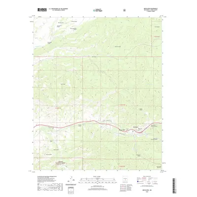
2020 Map of Mescalero
USGS Topo · Published 2020About this map
Mescalero and Bent anchor the canyon floors in this 2020 study of the high-altitude terrain where the Sacramento Mountains meet the southern edge of Sierra Blanca. The settlement pattern follows the life-giving waters of Tularosa Cr and its tributaries, which have carved deep drainages like Tularosa Canyon and Nogal Canyon. Cultural landmarks such as Blazers Mill and the Walters Cem sit near the valley floor, while names like Jose Carrillo Canyon and Pinkey Canyon reflect the complex history of land use and family heritage in the region. Much of the western and southern reaches are managed as part of the Lincoln National Forest, preserving the steep slopes and peaks, including Mtn Lion Peak. Modern travel routes such as Mescalero Blvd and Geronimo Loop provide access through the rugged topography, connecting the historic communities with the surrounding mountain landscape.
Find a feature on this map
41 named features on this map. Tap any name to fly to it.
Don’t see what you’re looking for? This feature index may not catch every label — zoom into the map to look around manually.
Map Details
Editions of this 2020 Mescalero Map
This is the sole edition of this map. No revisions or reprints were ever made.
Other maps of this area

1950 · Sierra Blanca Peak
USGS Topo · 1:62,500

1950 · Mescalero
USGS Topo · 1:62,500

1955 · Roswell
USGS Topo · 1:250,000

1958 · Roswell
USGS Topo · 1:250,000

1962 · Roswell
USGS Topo · 1:250,000

1963 · Ruidoso
USGS Topo · 1:24,000

1963 · Firman Canyon
USGS Topo · 1:24,000

1963 · Apache Summit
USGS Topo · 1:24,000
1981 · Golondrina Draw
USGS Topo · 1:24,000
1981 · Cat Mountain
USGS Topo · 1:24,000