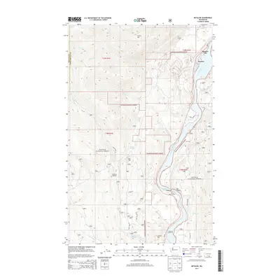
2014 Map of Metaline
USGS Topo · Published 2014About this map
The Pend Oreille River carves a deep valley through the Colville National Forest in this northeastern corner of Washington. The settlements of Metaline Falls and Metaline serve as the primary hubs of human activity, situated near where Flume Cr and Sweet Cr meet the main river. This landscape is defined by its significant relief, rising from the riverbanks to the summits of Linton Mtn and Deer Mtn. Local landmarks like the Box Canyon Dam Viewpoint and the Edgewater Campground indicate the river's role in both power generation and recreation. Small family or community markers, such as the Perkins Cem, are nestled on the eastern banks. Away from the water, the terrain is dotted with named clearings like Thorson Meadow and Cameron Meadow, connected by a network of forest roads including Cedar Creek Rd and Nat For Dev Rd.
Find a feature on this map
44 named features on this map. Tap any name to fly to it.
Don’t see what you’re looking for? This feature index may not catch every label — zoom into the map to look around manually.
Map Details
Editions of this 2014 Metaline Map
This is the sole edition of this map. No revisions or reprints were ever made.
Other maps of this area

1929 · Colville
USGS Topo · 1:125,000

1933 · Colville
USGS Topo · 1:125,000

1934 · Metaline
USGS Topo · 1:125,000

1942 · Metaline
USGS Topo · 1:125,000

1952 · Deep Lake
USGS Topo · 1:24,000

1952 · Leadpoint
USGS Topo · 1:24,000

1958 · Sandpoint
USGS Topo · 1:250,000

1963 · Sandpoint
USGS Topo · 1:250,000
1967 · Aladdin Mtn
USGS Topo · 1:24,000

1967 · Ione
USGS Topo · 1:24,000