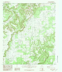
1984 Map of Metcalf Gap
USGS Topo · Published 1984About this map
The Palo Pinto Mountains dominate this 1980s landscape, characterized by the dramatic passage at Metcalf Gap and the prominent heights of Sugarloaf Mountain. This area of Palo Pinto County reveals a pattern of ranching and natural drainage where numerous waterways like Little Ioni Creek and Eagle Creek carve through the high ground. The map details the intricate topography of the Texas hill country, showing Antelope Mtn and the winding course of Honey Creek. Notable geographic features such as Springer Gap and Brushy Hollow illustrate the varied terrain that has historically shaped movement and settlement in this part of north-central Texas. The distribution of small branches and creeks, including Massey Branch and Walnut Creek, highlights the importance of water sources in this elevated environment.
Find a feature on this map
14 named features on this map. Tap any name to fly to it.
Don’t see what you’re looking for? This feature index may not catch every label — zoom into the map to look around manually.
Map Details
Editions of this 1984 Metcalf Gap Map
This is the sole edition of this map. No revisions or reprints were ever made.
Other maps of this area

1890 · Breckenridge
USGS Topo · 1:125,000

1891 · Palo Pinto
USGS Topo · 1:125,000

1918 · Palo Pinto
USGS Topo · 1:125,000

1924 · Palo Pinto 2-c
USGS Topo · 1:48,000

1924 · Breckenridge 1-d
USGS Topo · 1:48,000

1927 · Pickwick
USGS Topo · 1:62,500

1931 · Ivan
USGS Topo · 1:62,500

1954 · Abilene
USGS Topo · 1:250,000

1958 · Abilene
USGS Topo · 1:250,000

1958 · Palo Pinto
USGS Topo · 1:62,500