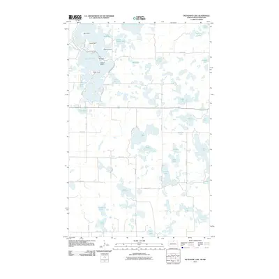
2011 Map of Metigoshe Lake
USGS Topo · Published 2011About this map
Metigoshe Lake dominates the upper-left corner of this landscape, its complex shoreline defined by prominent features like Rugby Point, Squaw Point, and The Narrows. This glacial lake system, controlled by the Lake Metigoshe Dam, is dotted with significant landmasses including Bear Island, Masonic Island, and Mackay Island. The surrounding terrain is a classic prairie pothole region, dense with smaller water bodies such as Pelican Lake, Loon Lake, and the aptly named School Section Lake.
Find a feature on this map
48 named features on this map. Tap any name to fly to it.
Don’t see what you’re looking for? This feature index may not catch every label — zoom into the map to look around manually.
Map Details
Editions of this 2011 Metigoshe Lake Map
This is the sole edition of this map. No revisions or reprints were ever made.
Other maps of this area

1935 · Dunseith
USGS Topo · 1:48,000

1939 · Dunseith
USGS Topo · 1:62,500

1954 · Minot
USGS Topo · 1:250,000

1955 · Lords Lake
USGS Topo · 1:24,000

1955 · Bottineau
USGS Topo · 1:24,000

1955 · Bottineau SE
USGS Topo · 1:24,000

1956 · Metigoshe Lake
USGS Topo · 1:24,000

1956 · Lake McArthur
USGS Topo · 1:24,000
1956 · Lords Lake
USGS Topo · 1:25,000

1958 · Minot
USGS Topo · 1:250,000