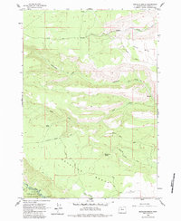
1962 Map of Metolius Bench
USGS Topo · Published 1983About this map
The Warm Springs Indian Reservation and Deschutes National Forest meet in this central Oregon landscape, dominated by the expansive plateaus of Metolius Bench and Tenino Bench. Surveyed in the early 1960s, the terrain is defined by a series of dramatic canyon descents toward the Metolius River, including the deep cut of Box Canyon. Water sources are vital markers in this arid environment, with named points like Peters Spring, Beachkomb Spring, and Horse Trap Spring providing critical locations for livestock and wildlife. Movement through the area relies on a network of unimproved routes such as Tenino Road and Horse Trap Road, alongside various jeep trails. Recreational development is evident near the southern boundary, where Monty Campground and Drift Campground offer access to the river's edge, reflecting the region's mid-century role as a destination for outdoor enthusiasts.
Find a feature on this map
26 named features on this map. Tap any name to fly to it.
Don’t see what you’re looking for? This feature index may not catch every label — zoom into the map to look around manually.
Map Details
Editions of this 1962 Metolius Bench Map
3 editions found
Other maps of this area

1927 · Mt. Jefferson
USGS Topo · 1:125,000

1928 · Madras
USGS Topo · 1:125,000

1930 · Mt. Jefferson
USGS Topo · 1:125,000

1931 · Madras
USGS Topo · 1:125,000

1955 · Bend
USGS Topo · 1:250,000

1957 · Bend
USGS Topo · 1:250,000

1958 · Bend
USGS Topo · 1:250,000

1961 · Whitewater River
USGS Topo · 1:62,500

1961 · Fort Butte
USGS Topo · 1:62,500

1962 · Metolius Bench
USGS Topo · 1:24,000