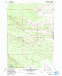
1962 Map of Metolius Bench
USGS Topo · Published 1994About this map
The Warm Springs Indian Reservation occupies much of this landscape, where the plateau terrain is defined by the broad surfaces of Tenino Bench and Metolius Bench. These high plains are dissected by a network of drainages including Tenino Creek and Seekseequa Creek, which flow toward the canyon of the Metolius River in the southwestern corner. The mapping shows a rugged environment of canyons and hollows, such as Dry Hollow and Box Canyon, where water sources like Peters Spring and Beachkomb Spring provided vital points of interest for early travel.
Find a feature on this map
27 named features on this map. Tap any name to fly to it.
Don’t see what you’re looking for? This feature index may not catch every label — zoom into the map to look around manually.
Map Details
Editions of this 1962 Metolius Bench Map
3 editions found
Other maps of this area

1927 · Mt. Jefferson
USGS Topo · 1:125,000

1928 · Madras
USGS Topo · 1:125,000

1930 · Mt. Jefferson
USGS Topo · 1:125,000

1931 · Madras
USGS Topo · 1:125,000

1955 · Bend
USGS Topo · 1:250,000

1957 · Bend
USGS Topo · 1:250,000

1958 · Bend
USGS Topo · 1:250,000

1961 · Whitewater River
USGS Topo · 1:62,500

1961 · Fort Butte
USGS Topo · 1:62,500

1962 · Metolius Bench
USGS Topo · 1:24,000