
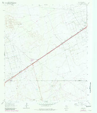
1964 Map of Metz
USGS Topo · Published 1967About this map
The Texas and Pacific railroad forms the primary industrial corridor through this West Texas landscape, connecting the small settlements of Metz and Judkins. In the mid-1960s, the region was defined by the extensive Metz Oil Field and surrounding petroleum infrastructure, evidenced by numerous pipelines and a Pumping Sta. The presence of a Roadside Park along the highway near Metz reflects the era's emerging travel culture in this arid environment.
Find a feature on this map
20 named features on this map. Tap any name to fly to it.
Don’t see what you’re looking for? This feature index may not catch every label — zoom into the map to look around manually.
Map Details
Editions of this 1964 Metz Map
2 editions found
Other maps of this area

1954 · Pecos
USGS Topo · 1:250,000

1957 · Pecos
USGS Topo · 1:250,000

1964 · Douro
USGS Topo · 1:24,000

1964 · Red Lakes
USGS Topo · 1:24,000

1964 · Penwell SW
USGS Topo · 1:24,000

1964 · Penwell
USGS Topo · 1:24,000

1964 · Penwell SE
USGS Topo · 1:24,000

1968 · Monahans SE
USGS Topo · 1:24,000

1968 · Cowden Place
USGS Topo · 1:24,000
1971 · Amburgey Ranch
USGS Topo · 1:24,000