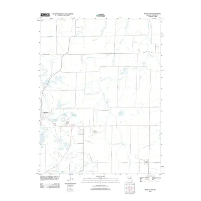
2012 Map of Mexico East
USGS Topo · Published 2012About this map
The South Fork Salt River defines the western edge of this Audrain County landscape, carving a path through the rolling agricultural terrain east of Mexico. The area is characterized by a high density of small water bodies and reservoirs, such as Burlington Lake, C and A Lake, and Number 101 Lake, which suggest a history of water management for local livestock and transport needs. To the southeast, the small settlement of Vandiver sits near the East Lawn Memorial Cemetery, while the Mexico Memorial Airport occupies a central position between the larger town and Benton City. The map details a transition from the structured urban outskirts of Mexico to an expansive network of rural county roads, including Audrain Road 808 and Pollock Rd, which bridge the numerous tributaries like Wildcat Creek and Bean Branch.
Find a feature on this map
51 named features on this map. Tap any name to fly to it.
Don’t see what you’re looking for? This feature index may not catch every label — zoom into the map to look around manually.
Map Details
Editions of this 2012 Mexico East Map
This is the sole edition of this map. No revisions or reprints were ever made.
Other maps of this area

1890 · Mexico
USGS Topo · 1:125,000

1932 · Mexico
USGS Topo · 1:62,500

1942 · Wellsville
USGS Topo · 1:62,500

1945 · Florida
USGS Topo · 1:62,500

1945 · Perry
USGS Topo · 1:62,500

1948 · Quincy
USGS Topo · 1:250,000

1956 · Quincy
USGS Topo · 1:250,000
1972 · Mexico East
USGS Topo · 1:24,000
1972 · Molino
USGS Topo · 1:24,000
1972 · Auxvasse
USGS Topo · 1:24,000