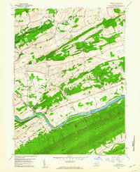
1959 Map of Mexico
USGS Topo · Published 1960About this map
The Juniata River carves through the central Pennsylvania landscape, serving as a corridor for the Pennsylvania Railroad and the William Penn Highway at the close of the 1950s. The settlement of Mexico anchors the riverbank near Allen Grove Camp, while the surrounding ridges and valleys are dotted with small agricultural communities and local landmarks. This area shows a pattern of rural development focused along watercourses and the gaps between Lost Creek Ridge and Tuscarora Mountain. Genealogists will find a high density of small family and community burial grounds, including the Rothrock Cem, Diven Cem, and Lantz Cem. Educational and religious life is well-documented through landmarks like the Kurtz Valley Sch and Pine Grove Ch, which served residents of townships like Walker and Fermanagh.
Find a feature on this map
51 named features on this map. Tap any name to fly to it.
Don’t see what you’re looking for? This feature index may not catch every label — zoom into the map to look around manually.
Map Details
Editions of this 1959 Mexico Map
4 editions found
Other maps of this area

1907 · New Bloomfield
USGS Topo · 1:62,500

1907 · Millerstown
USGS Topo · 1:62,500

1925 · Mifflintown
USGS Topo · 1:48,000

1930 · Loysville
USGS Topo · 1:62,500

1933 · Loysville
USGS Topo · 1:62,500

1934 · Mifflintown
USGS Topo · 1:62,500

1937 · Mifflintown
USGS Topo · 1:62,500

1943 · Millerstown
USGS Topo · 1:62,500

1943 · New Bloomfield
USGS Topo · 1:62,500

1950 · Harrisburg
USGS Topo · 1:250,000
Featured Places
- Tuscarora, Turbett Township
- Tuscarora Township, PA
- Fayette Township, PA
- Turbett Township, PA
- Delaware Township, PA