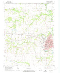
1972 Map of Mexico West
USGS Topo · Published 1974About this map
Mexico serves as the focal point of this Audrain County landscape, showing the city's western expansion and industrial connectivity during the early 1970s. The Illinois Central Gulf railroad cuts a straight path through the township, linking the urban center with the settlement of Thompson to the west. This transportation corridor is flanked by essential community landmarks, including the Courthouse, several local schools like Eugene Field School, and the historic grounds of St Brendans Cemetery and Elmwood Cemetery.
Find a feature on this map
56 named features on this map. Tap any name to fly to it.
Don’t see what you’re looking for? This feature index may not catch every label — zoom into the map to look around manually.
Map Details
Editions of this 1972 Mexico West Map
2 editions found
Other maps of this area

1890 · Mexico
USGS Topo · 1:125,000

1890 · Moberly
USGS Topo · 1:125,000

1932 · Mexico
USGS Topo · 1:62,500

1945 · Florida
USGS Topo · 1:62,500

1945 · Centralia
USGS Topo · 1:62,500

1948 · Quincy
USGS Topo · 1:250,000

1953 · Moberly
USGS Topo · 1:250,000

1954 · Moberly
USGS Topo · 1:250,000

1956 · Quincy
USGS Topo · 1:250,000

1957 · Moberly
USGS Topo · 1:250,000