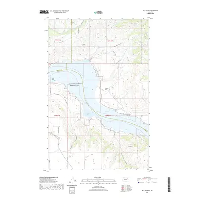
2020 Map of Mica Mountain
USGS Topo · Published 2020About this map
Franklin D Roosevelt Lake serves as the central geographic feature of this Washington landscape, where the waters of the Columbia River are contained within the Lake Roosevelt National Recreation Area. The map details a complex shoreline marked by Swawilla Cove, Cayuse Bay, and Wynhoff Cove. Rising sharply from the water's edge, the terrain is defined by significant elevations such as Mica Mtn and Sugarloaf, separated by deep drainage systems like Kwei Kwei Canyon and Niles Canyon. This 2020 survey reveals a network of land management and access, including Hideout Ranch Rd and Microwave Tower Rd, which navigate the steep topography of Seaton Canyon and the Swawilla Basin. The intersection of Okanogan, Ferry, and Lincoln counties meets within these waters, illustrating the jurisdictional complexity of this river-driven region.
Find a feature on this map
38 named features on this map. Tap any name to fly to it.
Don’t see what you’re looking for? This feature index may not catch every label — zoom into the map to look around manually.
Map Details
Editions of this 2020 Mica Mountain Map
This is the sole edition of this map. No revisions or reprints were ever made.
Other maps of this area

1948 · Grand Coulee Dam
USGS Topo · 1:62,500

1948 · Wilbur
USGS Topo · 1:62,500

1950 · Wilbur
USGS Topo · 1:62,500

1950 · Grand Coulee Dam
USGS Topo · 1:62,500

1950 · Nespelem
USGS Topo · 1:62,500

1952 · Keller
USGS Topo · 1:62,500

1953 · Ritzville
USGS Topo · 1:250,000

1954 · Okanogan
USGS Topo · 1:250,000

1958 · Okanogan
USGS Topo · 1:250,000

1959 · Ritzville
USGS Topo · 1:250,000