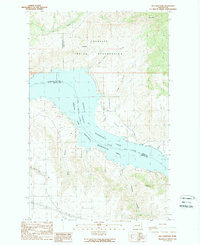
1989 Map of Mica Mountain
USGS Topo · Published 1989About this map
Franklin D Roosevelt Lake dominates this landscape, where the waters of the Columbia River are impounded within the Coulee Dam National Recreation Area. The map captures a point of convergence between the Colville Indian Reservation to the north and the rugged shoreline to the south. The terrain is marked by significant elevation changes, rising from the basin floor to high points like Mica Mtn and Meeker Mountain. Drainage patterns are defined by deep cuts such as Seaton Can and small tributaries like Peter Dan Creek and Kwai Kwei. Infrastructure is sparse in this protected area, though a Pumping Station and scattered gravel pits suggest the ongoing management of the lake's resources and the local transportation corridors that follow the winding lakefront.
Find a feature on this map
26 named features on this map. Tap any name to fly to it.
Don’t see what you’re looking for? This feature index may not catch every label — zoom into the map to look around manually.
Map Details
Editions of this 1989 Mica Mountain Map
This is the sole edition of this map. No revisions or reprints were ever made.
Other maps of this area

1948 · Grand Coulee Dam
USGS Topo · 1:62,500

1948 · Wilbur
USGS Topo · 1:62,500

1950 · Wilbur
USGS Topo · 1:62,500

1950 · Grand Coulee Dam
USGS Topo · 1:62,500

1950 · Nespelem
USGS Topo · 1:62,500

1952 · Keller
USGS Topo · 1:62,500

1953 · Ritzville
USGS Topo · 1:250,000

1954 · Okanogan
USGS Topo · 1:250,000

1958 · Okanogan
USGS Topo · 1:250,000

1959 · Ritzville
USGS Topo · 1:250,000