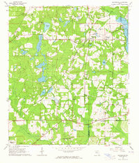
1963 Map of Miccosukee
USGS Topo · Published 1964About this map
Miccosukee serves as a central hub on the border of Leon and Jefferson counties, characterized by a transition from agricultural fields to the marshy expanse of Lake Miccosukee. The 1963 landscape is dotted with small rural communities like Wadesboro, Baum, and Concord, each anchored by foundational institutions such as the Concord School and several country churches, including Centenary Church and New Jerusalem Church.
Find a feature on this map
53 named features on this map. Tap any name to fly to it.
Don’t see what you’re looking for? This feature index may not catch every label — zoom into the map to look around manually.
Map Details
Editions of this 1963 Miccosukee Map
This is the sole edition of this map. No revisions or reprints were ever made.
Other maps of this area

1954 · Lloyd
USGS Topo · 1:24,000

1954 · Lafayette
USGS Topo · 1:24,000

1954 · Valdosta
USGS Topo · 1:250,000

1954 · Tallahassee
USGS Topo · 1:250,000

1955 · Waukeenah
USGS Topo · 1:24,000

1956 · Metcalf
USGS Topo · 1:24,000

1957 · Beachton
USGS Topo · 1:24,000

1957 · Miccosukee NE
USGS Topo · 1:24,000

1958 · Valdosta
USGS Topo · 1:250,000

1959 · Tallahassee
USGS Topo · 1:250,000