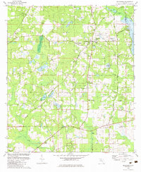
1982 Map of Miccosukee
USGS Topo · Published 1982About this map
Miccosukee and its surrounding rural landscapes in northern Florida are defined by a complex network of small ponds and wetlands, most notably the western shore of Lake Miccosukee. The area transitions from the high ground at Moccasin Gap and Homestead Ridge down to the watery basins of Alberta Lake, Shemonie Lake, and Cody Pond. Settlement is scattered across small hamlets like Felkel, Concord, and Wadesboro, connected by a series of named rural routes including Old Settlement Road and the uniquely named Bye Bye Road. Historic community life is centered on numerous local congregations and burial grounds, such as Indian Springs Ch, Mt Sinai Ch, and Runners Cem. A Railroad Grade and a Lookout Tower near the town center indicate the area's twentieth-century infrastructure and land management during this era of agricultural and timber production.
Find a feature on this map
54 named features on this map. Tap any name to fly to it.
Don’t see what you’re looking for? This feature index may not catch every label — zoom into the map to look around manually.
Map Details
Editions of this 1982 Miccosukee Map
This is the sole edition of this map. No revisions or reprints were ever made.
Other maps of this area

1954 · Lloyd
USGS Topo · 1:24,000

1954 · Lafayette
USGS Topo · 1:24,000

1954 · Valdosta
USGS Topo · 1:250,000

1954 · Tallahassee
USGS Topo · 1:250,000

1955 · Waukeenah
USGS Topo · 1:24,000

1956 · Metcalf
USGS Topo · 1:24,000

1957 · Beachton
USGS Topo · 1:24,000

1957 · Miccosukee NE
USGS Topo · 1:24,000

1958 · Valdosta
USGS Topo · 1:250,000

1959 · Tallahassee
USGS Topo · 1:250,000