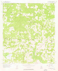
1957 Map of Miccosukee NE
USGS Topo · Published 1976About this map
The Georgia-Florida state line bisects this landscape, revealing a mid-century rural region defined by its dispersed religious centers and scattered ponds. In the northern section, within Grady and Thomas counties, small rural congregations like Mercy Seat Ch and Trinity Ch anchor the community, often situated near family burial grounds such as Copeland Cem and Spring Hill Cem. The terrain is characterized by a series of significant water bodies, including the prominent Foshalee Lake in the southwest and a network of smaller basins like Gin House Pond and Ferguson Pond.
Find a feature on this map
29 named features on this map. Tap any name to fly to it.
Don’t see what you’re looking for? This feature index may not catch every label — zoom into the map to look around manually.
Map Details
Editions of this 1957 Miccosukee NE Map
2 editions found
Other maps of this area

1954 · Valdosta
USGS Topo · 1:250,000

1954 · Tallahassee
USGS Topo · 1:250,000

1956 · Cairo
USGS Topo · 1:62,500

1956 · Metcalf
USGS Topo · 1:24,000

1957 · Beachton
USGS Topo · 1:24,000

1957 · Miccosukee NE
USGS Topo · 1:24,000

1957 · Thomasville
USGS Topo · 1:62,500

1958 · Valdosta
USGS Topo · 1:250,000

1959 · Tallahassee
USGS Topo · 1:250,000

1959 · Valdosta
USGS Topo · 1:250,000