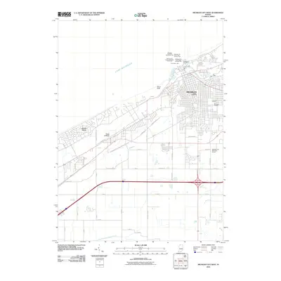
2010 Map of Michigan City West
USGS Topo · Published 2010About this map
Lake Michigan dominates the northern horizon of this coastal Indiana landscape, where the shifting sands of Mount Baldy overlook a complex network of harbor infrastructure and residential growth. In Michigan City, the harbor entrance is defined by a series of navigational aids, including the Michigan City Harbor Breakwater Light and the Michigan City Harbor East Pierhead Light, marking the transition from the lake to the Washington Park Marina and the mouth of Trail Creek. To the west, the residential patterns of Beverly Shores and the Town of Pines are hemmed in by the lake shore and a dense corridor of transportation routes, including the E Dunes Hwy and Railroad Ave. Further inland, the map captures the transition to a more structured grid near the Michigan City Municipal Airport and historical sites such as Greenwood Cemetery and Saint Stanislaus Cemetery, while the East Arm Little Calumet River meanders through the southern reaches of the quadrangle.
Find a feature on this map
45 named features on this map. Tap any name to fly to it.
Don’t see what you’re looking for? This feature index may not catch every label — zoom into the map to look around manually.
Map Details
Editions of this 2010 Michigan City West Map
This is the sole edition of this map. No revisions or reprints were ever made.
Other maps of this area

1934 · Porter
USGS Topo · 1:48,000

1940 · Porter
USGS Topo · 1:62,500

1953 · Westville
USGS Topo · 1:24,000

1953 · Chesterton
USGS Topo · 1:24,000

1953 · Dune Acres
USGS Topo · 1:24,000

1953 · Michigan City West
USGS Topo · 1:24,000

1953 · Chicago
USGS Topo · 1:250,000

1957 · Chicago
USGS Topo · 1:250,000

1958 · Michigan City East
USGS Topo · 1:24,000
1961 · La Porte West
USGS Topo · 1:24,000