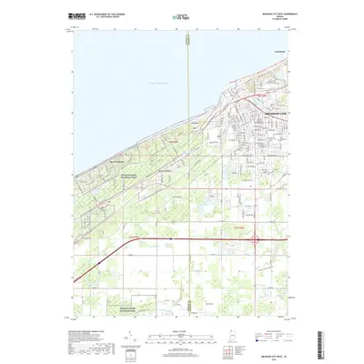
2019 Map of Michigan City West
USGS Topo · Published 2019About this map
The transition between the industrial hub of Michigan City and the protected shoreline of Indiana Dunes National Park defines this 2019 survey. The map details the residential expansion of lakeside communities like Long Beach and Beverly Shores, where a dense grid of streets meets the open expanse of Lake Michigan. Further inland, the Town of Pines and the small enclave of Ter Acres sit amidst a landscape shaped by drainage features such as Carver Ditch and the E Arm Little Calumet River. Local genealogy and land-use history are anchored by the presence of Greenwood Cem and Saint Stanislaus Cem on the eastern edge. For recreation and conservation enthusiasts, the map traces the Calumet Trail and highlights the prominence of Mt Baldy, one of the most recognizable landmarks along the southern shore.
Find a feature on this map
64 named features on this map. Tap any name to fly to it.
Don’t see what you’re looking for? This feature index may not catch every label — zoom into the map to look around manually.
Map Details
Editions of this 2019 Michigan City West Map
This is the sole edition of this map. No revisions or reprints were ever made.
Other maps of this area

1934 · Porter
USGS Topo · 1:48,000

1940 · Porter
USGS Topo · 1:62,500

1953 · Westville
USGS Topo · 1:24,000

1953 · Chesterton
USGS Topo · 1:24,000

1953 · Dune Acres
USGS Topo · 1:24,000

1953 · Michigan City West
USGS Topo · 1:24,000

1953 · Chicago
USGS Topo · 1:250,000

1957 · Chicago
USGS Topo · 1:250,000

1958 · Michigan City East
USGS Topo · 1:24,000
1961 · La Porte West
USGS Topo · 1:24,000