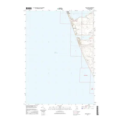
2017 Map of Michillinda
USGS Topo · Published 2017About this map
Lake Michigan dominates the western half of this Michigan shoreline landscape, where the shifting sands and coastal forests meet the established communities of Muskegon County. Along the narrow strip of land separating the great lake from inland waters, the settlements of Wabaningo, Sylvan Beach, and Michillinda illustrate a dense pattern of coastal development. The map details a network of residential roads like N Scenic Dr and W Michillinda Rd that navigate the high ground between the shoreline and the marshy edges of White Lake and Duck Lake. Local history is anchored by the Duck Lake Cem located just inland from the coast, while Strawberry Cr drains the northern reaches of the quadrangle. The terrain is defined by its proximity to these major water bodies, reflecting a late-2010s perspective on a region long shaped by seasonal tourism and residential growth.
Find a feature on this map
24 named features on this map. Tap any name to fly to it.
Don’t see what you’re looking for? This feature index may not catch every label — zoom into the map to look around manually.
Map Details
Editions of this 2017 Michillinda Map
This is the sole edition of this map. No revisions or reprints were ever made.
Other maps of this area

1929 · Montague
USGS Topo · 1:48,000

1930 · Lake Harbor
USGS Topo · 1:48,000

1936 · Lake Harbor
USGS Topo · 1:62,500

1954 · Milwaukee
USGS Topo · 1:250,000

1958 · Milwaukee
USGS Topo · 1:250,000

1959 · Montague
USGS Topo · 1:62,500
1972 · Muskegon West
USGS Topo · 1:24,000

1976 · Montague NW
USGS Topo · 1:24,000
1976 · Montague SW
USGS Topo · 1:24,000
1976 · Montague NE
USGS Topo · 1:24,000
Featured Places
- Wabaningo, MI
- White River Township, MI
- Fruitland Township, MI
- Laketon Township, MI
- Montague Township, MI