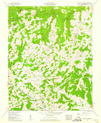
1959 Map of Middle Fox Creek
USGS Topo · Published 1960About this map
Jefferson National Forest dominates the northern reaches of this territory, where the Smyth Co Grayson Co line traverses the high peaks of Iron Mountain. The landscape is a dense network of ridges and hollows, characterized by numerous rural congregations and family burial grounds that speak to the deep-rooted settlement patterns of the late 1950s. Small communities like Flat Ridge and Barton Crossroads serve as anchors in a terrain defined by landmarks such as Russell Knob and High Rock.
Find a feature on this map
77 named features on this map. Tap any name to fly to it.
Don’t see what you’re looking for? This feature index may not catch every label — zoom into the map to look around manually.
Map Details
Editions of this 1959 Middle Fox Creek Map
4 editions found
Other maps of this area

1889 · Wytheville
USGS Topo · 1:125,000

1892 · Wytheville
USGS Topo · 1:125,000

1930 · Speedwell
USGS Topo · 1:62,500

1930 · Independence
USGS Topo · 1:48,000

1931 · Rural Retreat
USGS Topo · 1:48,000

1933 · Independence
USGS Topo · 1:62,500

1935 · Mouth of Wilson
USGS Topo · 1:48,000

1935 · Cedar Springs
USGS Topo · 1:24,000
1935 · Trout Dale
USGS Topo · 1:24,000
1935 · Atkins
USGS Topo · 1:24,000