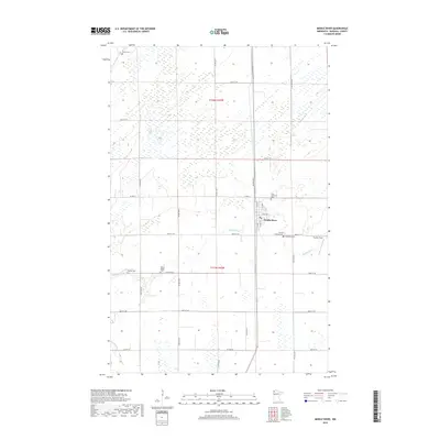
2019 Map of Middle River
USGS Topo · Published 2019About this map
The town of Middle River sits at the heart of this Marshall County survey, where the winding waterway of the Middle River cuts through the flat agricultural landscape. This 2019 survey documents a community deeply rooted in its local heritage, evidenced by the numerous burial grounds scattered across the surrounding sections. Local history is reflected in the placement of the First Lutheran Cem, Finnish Lutheran Cem, and the Spruce Valley Cem, which speak to the area’s settlement patterns and cultural origins. Away from the central township, landmarks like Chanlin Field and several smaller family or community cemeteries, including Huntly Cem and Gaarde Cem, are connected by a rigid grid of rural routes such as Co HWY 6 and 370th ST Ne. This modern digital survey provides a clear view of the prairie's conversion to structured farmland while maintaining the geographic markers of its early inhabitants.
Find a feature on this map
24 named features on this map. Tap any name to fly to it.
Don’t see what you’re looking for? This feature index may not catch every label — zoom into the map to look around manually.
Map Details
Editions of this 2019 Middle River Map
This is the sole edition of this map. No revisions or reprints were ever made.
Other maps of this area

1918 · Greenbush
USGS Topo · 1:62,500

1918 · Middle River
USGS Topo · 1:62,500

1919 · Pelan
USGS Topo · 1:62,500

1952 · Thief River Falls
USGS Topo · 1:250,000

1956 · Thief River Falls
USGS Topo · 1:250,000

1957 · Thief River Falls
USGS Topo · 1:250,000

1957 · Newfolden
USGS Topo · 1:62,500

1957 · Pelan
USGS Topo · 1:62,500
1961 · Middle River NE
USGS Topo · 1:24,000
1961 · Middle River SE
USGS Topo · 1:24,000