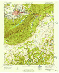
1955 Map of Middlesboro South
USGS Topo · Published 1956About this map
Cumberland Gap serves as the focal point of this mid-century survey, where the borders of Kentucky, Tennessee, and Virginia converge along the steep ridge of Cumberland Mountain. The map illustrates the region's deep connection to early American transit, showing the Old Wilderness Road and Daniel Boone Trail winding through the gap. In the valley below, the campus of Lincoln Memorial University sits near the town of Harrogate, while to the north, the industrial layout of Middlesboro is defined by a rigid street grid including Cumberland Avenue and multiple rail lines of the Louisville and Nashville and Southern railroads.
Find a feature on this map
82 named features on this map. Tap any name to fly to it.
Don’t see what you’re looking for? This feature index may not catch every label — zoom into the map to look around manually.
Map Details
Editions of this 1955 Middlesboro South Map
This is the sole edition of this map. No revisions or reprints were ever made.
Other maps of this area

1886 · Cumberland Gap
USGS Topo · 1:125,000

1888 · Cumberland Gap
USGS Topo · 1:125,000

1891 · Cumberland Gap
USGS Topo · 1:125,000

1897 · Maynardville
USGS Topo · 1:125,000

1900 · Maynardville
USGS Topo · 1:125,000

1903 · Middlesboro
USGS Topo · 1:48,000

1927 · Middlesboro
USGS Topo · 1:62,500

1930 · Middlesboro
USGS Topo · 1:62,500

1935 · Varilla
USGS Topo · 1:24,000

1935 · Mingo Mountains
USGS Topo · 1:24,000