
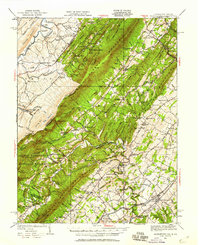
1937 Map of Middletown
USGS Topo · Published 1937About this map
Rock Enon Springs and the northern reaches of the Shenandoah Valley characterize this 1930s survey, showing a landscape defined by sharp ridges and deep-seated history. The map documents the intricate river systems of Cedar Creek and Opequon Creek, which once powered the region's early industries and mills. Near the southern edge, the Cedar Creek Battlefield and Harmony Hall mark significant historical grounds, while the presence of Nieswanders Fort points to the area's frontier past. Small settlements like Star Tannery, Marlboro, and Wheatfield are shown in detail, connected by the Memorial Highway and the Baltimore and Ohio railroad. This survey captures a mix of rural community life and mountain industry, including the Va Glass Sand Co Mine and numerous family-named crossings such as Mahaneys Ford and Beelers Ford.
Find a feature on this map
88 named features on this map. Tap any name to fly to it.
Don’t see what you’re looking for? This feature index may not catch every label — zoom into the map to look around manually.
Map Details
Editions of this 1937 Middletown Map
2 editions found
Other maps of this area

1891 · Romney
USGS Topo · 1:125,000

1892 · Woodstock
USGS Topo · 1:125,000

1893 · Luray
USGS Topo · 1:125,000

1894 · Winchester
USGS Topo · 1:125,000

1905 · Luray
USGS Topo · 1:125,000

1914 · Gerrardstown
USGS Topo · 1:48,000

1916 · Gerrardstown
USGS Topo · 1:62,500

1916 · Capon Bridge
USGS Topo · 1:62,500

1921 · Hanging Rock
USGS Topo · 1:48,000

1922 · Wardensville
USGS Topo · 1:62,500