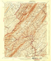
1943 Map of Middletown
USGS Topo · Published 1943About this map
North Mountain dominates the center of this terrain, dividing the watersheds of the Cacapon River and Cedar Creek. The 1943 survey details a landscape defined by its thermal springs and historical military sites, notably the Cedar Creek Battlefield and Harmony Hall near the junction of Frederick and Shenandoah counties. Local industry is visible in the operation of the A Glass Sand Co Mine and the small settlement of Star Tannery.
Find a feature on this map
143 named features on this map. Tap any name to fly to it.
Don’t see what you’re looking for? This feature index may not catch every label — zoom into the map to look around manually.
Map Details
Editions of this 1943 Middletown Map
2 editions found

Other maps of this area

1891 · Romney
USGS Topo · 1:125,000

1892 · Woodstock
USGS Topo · 1:125,000

1893 · Luray
USGS Topo · 1:125,000

1894 · Winchester
USGS Topo · 1:125,000

1905 · Luray
USGS Topo · 1:125,000

1914 · Gerrardstown
USGS Topo · 1:48,000

1916 · Gerrardstown
USGS Topo · 1:62,500

1916 · Capon Bridge
USGS Topo · 1:62,500

1921 · Hanging Rock
USGS Topo · 1:48,000

1922 · Wardensville
USGS Topo · 1:62,500