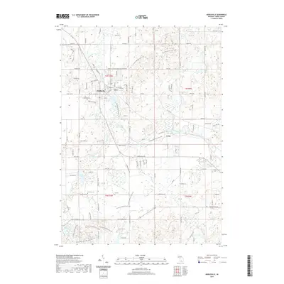
2019 Map of Middleville
USGS Topo · Published 2019About this map
The Thornapple River winds through this West Michigan landscape, anchoring the village of Middleville and the settlement of Irving. This 2019 survey documents a region characterized by its glaciated hydrology, where numerous water bodies like Bassett Lake, Shaw Lake, and Hathaway Lake break the terrain. The presence of several historic burial grounds, including Mount Hope Cem and Hill Cem, offers significant detail for local researchers and genealogists tracing the legacy of Barry County families. The map also highlights the complex network of creeks that feed the river system, such as Duncan Cr and Glass Cr, while marking the grid of rural roads including Finkbeiner Rd and Whitneyville Rd that connect these agricultural and residential communities.
Find a feature on this map
114 named features on this map. Tap any name to fly to it.
Don’t see what you’re looking for? This feature index may not catch every label — zoom into the map to look around manually.
Map Details
Editions of this 2019 Middleville Map
This is the sole edition of this map. No revisions or reprints were ever made.
Other maps of this area

1914 · Grand Rapids
USGS Topo · 1:62,500

1918 · Lowell
USGS Topo · 1:62,500

1943 · Grand Rapids
USGS Topo · 1:62,500

1943 · Lowell
USGS Topo · 1:62,500

1951 · Hastings
USGS Topo · 1:62,500

1958 · Grand Rapids
USGS Topo · 1:250,000

1959 · Wayland
USGS Topo · 1:62,500

1961 · Grand Rapids
USGS Topo · 1:250,000

1962 · Grand Rapids
USGS Topo · 1:250,000
1967 · Caledonia
USGS Topo · 1:24,000