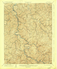
1909 Map of Midkiff
USGS Topo · Published 1931About this map
The Guyandot River carves a winding path through this corner of West Virginia, serving as the primary geographic anchor for numerous small river-side communities. Surveyed in the first decade of the twentieth century, the map captures a landscape defined by sharp ridges and deep hollows, where life centered on the floodplains and the confluence of tributary streams. Small centers of activity like Branchland, Midkiff, and the combined settlement of Laverne PO Brown City show the early development of the region's postal and residential network along the river banks.
Find a feature on this map
117 named features on this map. Tap any name to fly to it.
Don’t see what you’re looking for? This feature index may not catch every label — zoom into the map to look around manually.
Map Details
Editions of this 1909 Midkiff Map
3 editions found

Other maps of this area

1887 · Warfield
USGS Topo · 1:125,000

1891 · Oceana
USGS Topo · 1:125,000

1891 · Warfield
USGS Topo · 1:125,000

1892 · Huntington
USGS Topo · 1:125,000

1893 · Oceana
USGS Topo · 1:125,000

1898 · Huntington
USGS Topo · 1:125,000

1898 · Oceana
USGS Topo · 1:125,000

1899 · Charleston
USGS Topo · 1:125,000

1901 · Guyandot
USGS Topo · 1:62,500

1902 · Guyandot
USGS Topo · 1:62,500