
1968 Map of Midkiff SW
USGS Topo · Published 1970About this map
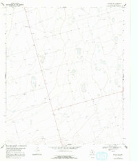
Industrial activity defines this corner of Upton County in the late 1960s, where the landscape is marked by a pervasive network of Oil Wells and extractive infrastructure. The terrain is largely dominated by the Field designation, indicating the significant petroleum interests of the Permian Basin during this era. Scattered across the topographical contours are numerous Gravel Pits, pointing to the ongoing maintenance of the local road network and industrial sites.
Find a feature on this map
4 named features on this map. Tap any name to fly to it.
Don’t see what you’re looking for? This feature index may not catch every label — zoom into the map to look around manually.
Map Details
Editions of this 1968 Midkiff SW Map
2 editions found
Other maps of this area

1928 · Crane
USGS Topo · 1:125,000

1928 · Rankin
USGS Topo · 1:125,000

1954 · Pecos
USGS Topo · 1:250,000

1954 · San Angelo
USGS Topo · 1:250,000

1957 · Pecos
USGS Topo · 1:250,000

1958 · San Angelo
USGS Topo · 1:250,000

1965 · San Angelo
USGS Topo · 1:250,000

1967 · Midkiff
USGS Topo · 1:24,000

1968 · Benge Corner SE
USGS Topo · 1:24,000

1968 · Midkiff NW
USGS Topo · 1:24,000