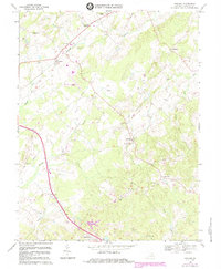
1967 Map of Midland
USGS Topo · Published 1984About this map
The John Marshall Birthplace marks a significant historical waypoint in this section of Fauquier County, where the Piedmont landscape is defined by the winding courses of Licking Run and Elk Run. Small agricultural settlements and crossroads like Germantown, Eustaces Corner, and Lois are connected by a network of rural roads and the tracks of the Southern railroad. The map reveals a community centered around its local institutions, including the Southeastern Sch and various houses of worship such as Calverton Ch and Mt Carmel Ch.
Find a feature on this map
35 named features on this map. Tap any name to fly to it.
Don’t see what you’re looking for? This feature index may not catch every label — zoom into the map to look around manually.
Map Details
Editions of this 1967 Midland Map
3 editions found
Other maps of this area

1887 · Spottsylvania
USGS Topo · 1:125,000

1892 · Spottsylvania
USGS Topo · 1:125,000

1894 · Warrenton
USGS Topo · 1:125,000

1894 · Warrenton
USGS Topo · 1:62,500

1927 · Remington
USGS Topo · 1:48,000

1930 · Warrenton
USGS Topo · 1:62,500

1943 · Catlett
USGS Topo · 1:62,500

1943 · Germanna Bridge
USGS Topo · 1:24,000

1943 · Midland
USGS Topo · 1:24,000
1944 · Midland
USGS Topo · 1:31,680