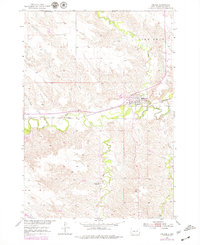
1954 Map of Midland
USGS Topo · Published 1979About this map
Midland serves as the central hub of this West River South Dakota landscape, situated at the confluence of the Bad River and Mitchell Creek. The town's reliance on the rails and regional education is evident, with the Chicago and North Western railroad cutting through the valley and local institutions like the Midland Cem and Eureka Sch dotting the surrounding prairie. A notable indicator of changing rural demographics is the Center Sch (Abandoned) located south of town along Braze Creek, marking a shift in the local school system by the mid-1950s.
Find a feature on this map
16 named features on this map. Tap any name to fly to it.
Don’t see what you’re looking for? This feature index may not catch every label — zoom into the map to look around manually.
Map Details
Editions of this 1954 Midland Map
Other maps of this area

1953 · Belvidere NE
USGS Topo · 1:24,000

1954 · Midland
USGS Topo · 1:24,000

1954 · Nowlin
USGS Topo · 1:24,000

1954 · Midland SE
USGS Topo · 1:24,000

1954 · Pierre
USGS Topo · 1:250,000

1955 · Martin
USGS Topo · 1:250,000

1958 · Pierre
USGS Topo · 1:250,000

1958 · Martin
USGS Topo · 1:250,000

1972 · Stamford NW
USGS Topo · 1:24,000
1972 · Stamford
USGS Topo · 1:24,000