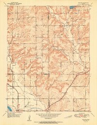
1951 Map of Midland
USGS Topo · Published 1951About this map
Midland sits at the heart of this post-war landscape where the boundaries of Sarcoxie and Tonganoxie meet. The terrain is defined by the winding course of Mud Creek and the notable elevation of Knowledge Hill, while the southern edge of the survey is anchored by the Kansas River. This era shows a community structured around a dense network of country school districts, including Knowledge Hill Sch, Mound Sch, and Oak Ridge Sch, many of which served rural farm families before mid-century school consolidations.
Find a feature on this map
30 named features on this map. Tap any name to fly to it.
Don’t see what you’re looking for? This feature index may not catch every label — zoom into the map to look around manually.
Map Details
Editions of this 1951 Midland Map
This is the sole edition of this map. No revisions or reprints were ever made.
Other maps of this area

1885 · Lawrence
USGS Topo · 1:125,000

1886 · Oskaloosa
USGS Topo · 1:125,000

1888 · Oskaloosa
USGS Topo · 1:125,000

1889 · Lawrence
USGS Topo · 1:125,000

1894 · Oskaloosa
USGS Topo · 1:125,000

1947 · Lawrence
USGS Topo · 1:250,000

1948 · Jarbalo
USGS Topo · 1:24,000

1949 · Williamstown
USGS Topo · 1:24,000

1950 · Kansas City
USGS Topo · 1:250,000

1950 · Williamstown
USGS Topo · 1:24,000