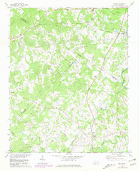
1971 Map of Midland
USGS Topo · Published 1981About this map
The Norfolk Southern corridor anchors this landscape, cutting through Midland and Allen as the region transitioned from a purely agrarian economy toward suburban development. The map reveals a dense network of spiritual and social hubs, from Bethel Ch and Bethel Sch in the north to the Macedonia Ch and Hopewell Ch. Small farming communities like Brief and Fairview are interspersed with family-named landmarks like Wiley Branch and Sherman Branch, which feed into larger water systems like Clear Creek and the Rocky River. Notable genealogical resources include established burial grounds such as Union Cem and Mill Grove Ch Cem. Topographic revisions shown in purple reflect the early expansion of Mint Hill and the introduction of local airstrips, signaling the changing character of the Piedmont during the 1970s.
Find a feature on this map
36 named features on this map. Tap any name to fly to it.
Don’t see what you’re looking for? This feature index may not catch every label — zoom into the map to look around manually.
Map Details
Editions of this 1971 Midland Map
3 editions found
Other maps of this area

1941 · Charlotte
USGS Topo · 1:125,000

1942 · Charlotte
USGS Topo · 1:125,000

1949 · Harrisburg
USGS Topo · 1:24,000

1949 · Wilgrove
USGS Topo · 1:24,000

1949 · Midland
USGS Topo · 1:24,000

1949 · Concord SE
USGS Topo · 1:24,000

1953 · Charlotte
USGS Topo · 1:250,000

1954 · Charlotte
USGS Topo · 1:250,000

1957 · Mount Pleasant
USGS Topo · 1:62,500

1960 · Charlotte
USGS Topo · 1:250,000