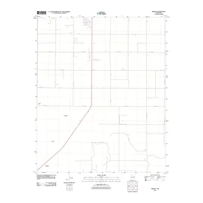
2010 Map of Midway
USGS Topo · Published 2010About this map
Midway and the surrounding high plains of Roosevelt County are defined by a rigid grid of agricultural roads and isolated ranching outposts. The landscape's development is structured by cardinal-direction thoroughfares such as County Rd 6 and Curry Road 3, which facilitate transit across this expansive territory. Historic property footprints are preserved through labels like Hardwick Ranch and Stewart Ranch, providing a window into the land use of the early 21st century. The diagonal passage of a primary roadway through Cameo creates a rare break in the geometric precision of the township lines, marking a historical corridor for transport between regional hubs. This survey documents the intersection of rural infrastructure and residential holdings in the eastern reaches of New Mexico.
Find a feature on this map
24 named features on this map. Tap any name to fly to it.
Don’t see what you’re looking for? This feature index may not catch every label — zoom into the map to look around manually.
Map Details
Editions of this 2010 Midway Map
This is the sole edition of this map. No revisions or reprints were ever made.
Other maps of this area

1954 · Clovis
USGS Topo · 1:250,000

1957 · Portair
USGS Topo · 1:62,500

1957 · Clovis
USGS Topo · 1:62,500

1957 · Arch
USGS Topo · 1:62,500

1957 · Portales
USGS Topo · 1:62,500

1958 · Clovis
USGS Topo · 1:250,000

1985 · Portair
USGS Topo · 1:24,000

1985 · Midway
USGS Topo · 1:24,000

1985 · Pleasure Lake
USGS Topo · 1:24,000
1985 · Farwell
USGS Topo · 1:24,000