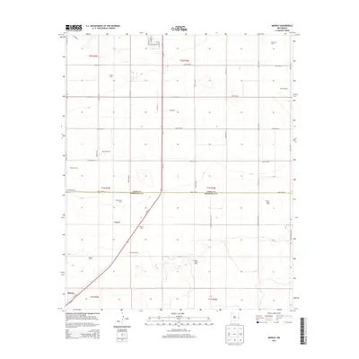
2013 Map of Midway
USGS Topo · Published 2013About this map
Midway and the surrounding high plains of Curry and Roosevelt counties are defined by a specialized agricultural economy concentrated along the Us-70 corridor. This modern survey illustrates a landscape dominated by extensive dairy operations and ranching, reflecting the region's role in New Mexico's commercial milk production. Large-scale facilities such as Rio Leche Dairy, Grande Vida Dairy, and Heritage Dairy are spaced across the gridded section lines, while traditional landholdings like Stewart Ranch and Hardwick Ranch maintain the area's cattle-raising heritage. The settlement of Cameo sits near the rail line and highway, serving as a focal point for this rural industrial network. The geometric precision of the road system, including Curry Road 5 and N Roosevelt Road G, underscores the systematic development of the Llano Estacado for high-output agriculture and grazing.
Find a feature on this map
45 named features on this map. Tap any name to fly to it.
Don’t see what you’re looking for? This feature index may not catch every label — zoom into the map to look around manually.
Map Details
Editions of this 2013 Midway Map
This is the sole edition of this map. No revisions or reprints were ever made.
Other maps of this area

1954 · Clovis
USGS Topo · 1:250,000

1957 · Portair
USGS Topo · 1:62,500

1957 · Clovis
USGS Topo · 1:62,500

1957 · Arch
USGS Topo · 1:62,500

1957 · Portales
USGS Topo · 1:62,500

1958 · Clovis
USGS Topo · 1:250,000

1985 · Portair
USGS Topo · 1:24,000

1985 · Midway
USGS Topo · 1:24,000

1985 · Pleasure Lake
USGS Topo · 1:24,000
1985 · Farwell
USGS Topo · 1:24,000