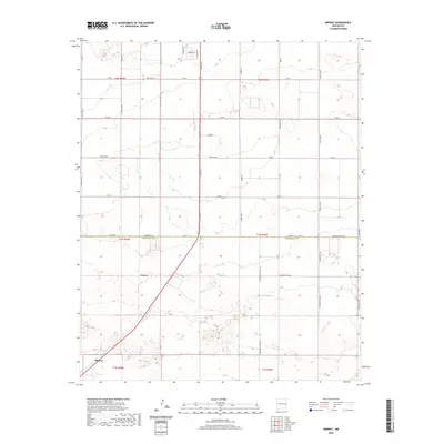
2020 Map of Midway
USGS Topo · Published 2020About this map
Midway and Cameo anchor this landscape along the southwestern boundary where the high plains transition between counties. The area is defined by a rigorous grid of section lines and rural thoroughfares like S Prince St and Curry Road 5, reflecting the agricultural organization of the Llano Estacado. A notable local landmark, the Swift-Plant-Rd, points to the industrial cattle and processing heritage of this corner of New Mexico. The map clearly delineates the Curry Co Roosevelt Co line, showing how the regional geometry of townships and ranges dictates the placement of modern roads and property boundaries. The terrain is marked by gentle depressions and subtle draws, including the residential developments along S Fork Dr near the northern edge.
Find a feature on this map
42 named features on this map. Tap any name to fly to it.
Don’t see what you’re looking for? This feature index may not catch every label — zoom into the map to look around manually.
Map Details
Editions of this 2020 Midway Map
This is the sole edition of this map. No revisions or reprints were ever made.
Other maps of this area

1954 · Clovis
USGS Topo · 1:250,000

1957 · Portair
USGS Topo · 1:62,500

1957 · Clovis
USGS Topo · 1:62,500

1957 · Arch
USGS Topo · 1:62,500

1957 · Portales
USGS Topo · 1:62,500

1958 · Clovis
USGS Topo · 1:250,000

1985 · Portair
USGS Topo · 1:24,000

1985 · Midway
USGS Topo · 1:24,000

1985 · Pleasure Lake
USGS Topo · 1:24,000
1985 · Farwell
USGS Topo · 1:24,000