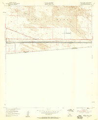
1954 Map of Midway Well
USGS Topo · Published 1959About this map
Midway Well sits at the heart of this mid-century desert landscape, serving as a critical waypoint in a region defined by its harsh environment and engineering efforts. The terrain is dominated by the shifting Sand Dunes of the East Mesa, which transition sharply into the industrial corridor of the All American Canal. This massive water infrastructure is documented in detail, featuring technical landmarks like Power Drop No 2, Power Drop No 3, and a Siphon, reflecting the era's focus on desert reclamation. Just north of the United States Mexico border, agricultural testing is evident at Experimental Farm No 1 and Experimental Farm No 2, suggesting early attempts to cultivate the arid soil using canal water. A network of Jeep Trails and a system of Levees further illustrate the human footprint on this borderland frontier.
Find a feature on this map
16 named features on this map. Tap any name to fly to it.
Don’t see what you’re looking for? This feature index may not catch every label — zoom into the map to look around manually.
Map Details
Editions of this 1954 Midway Well Map
4 editions found
Other maps of this area

1903 · Yuma
USGS Topo · 1:125,000

1905 · Yuma
USGS Topo · 1:125,000

1907 · Holtville
USGS Topo · 1:125,000

1942 · El Centro
USGS Topo · 1:250,000

1942 · Yuma
USGS Topo · 1:250,000

1953 · Grays Well
USGS Topo · 1:24,000

1953 · Ogilby
USGS Topo · 1:62,500

1953 · Cactus
USGS Topo · 1:24,000

1954 · El Centro
USGS Topo · 1:250,000

1954 · Midway Well NW
USGS Topo · 1:24,000