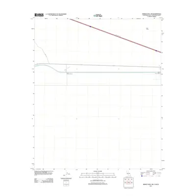
2012 Map of Midway Well NW
USGS Topo · Published 2012About this map
East Mesa dominates this arid landscape at the border, revealing the infrastructure required for power and transport in a desert environment. The map highlights critical water and energy management points, specifically Power Drop Number Four and Power Drop Number Three, which sit along the canal systems that define the region's geography. Transportation across this stretch is anchored by the diagonal path of Evan Hewes Hwy and the branching Desert Rd. This survey, conducted by the U.S. Geological Survey, uses data from the International Boundary and Water Commission to record the precise terrain where industrial utility meets the open desert.
Find a feature on this map
5 named features on this map. Tap any name to fly to it.
Don’t see what you’re looking for? This feature index may not catch every label — zoom into the map to look around manually.
Map Details
Editions of this 2012 Midway Well NW Map
This is the sole edition of this map. No revisions or reprints were ever made.
Other maps of this area

1907 · Holtville
USGS Topo · 1:125,000

1940 · Alamorio
USGS Topo · 1:62,500

1940 · Calexico
USGS Topo · 1:62,500

1942 · El Centro
USGS Topo · 1:250,000

1943 · Calexico
USGS Topo · 1:62,500

1945 · Alamorio
USGS Topo · 1:62,500
1953 · Calexico
USGS Topo · 1:50,000

1954 · El Centro
USGS Topo · 1:250,000

1954 · Midway Well NW
USGS Topo · 1:24,000
1954 · Glamis SE
USGS Topo · 1:24,000