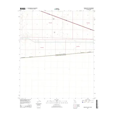
2015 Map of Midway Well NW
USGS Topo · Published 2015About this map
The United States of America Estados Unidos Mexicanos international border defines the southern landscape of this 2015 study area in Imperial County, California. This arid region, characterized by the Imperial Valley and the sandy expanse of East Mesa, is dominated by major water management and transportation corridors. The All-American Canal cuts a distinct horizontal line across the center of the map, serving as a critical artery for irrigation in this desert environment. Above the canal, two primary transit routes, Interstate 8 and State Route 98, traverse the terrain, illustrating the modern infrastructure that connects this borderland to the broader California interior. The map clearly delineates township and range lines, such as t16s r17e and t17s r18e, providing a precise grid of the public land survey system in this sparsely settled frontier.
Find a feature on this map
12 named features on this map. Tap any name to fly to it.
Don’t see what you’re looking for? This feature index may not catch every label — zoom into the map to look around manually.
Map Details
Editions of this 2015 Midway Well NW Map
This is the sole edition of this map. No revisions or reprints were ever made.
Other maps of this area

1907 · Holtville
USGS Topo · 1:125,000

1940 · Alamorio
USGS Topo · 1:62,500

1940 · Calexico
USGS Topo · 1:62,500

1942 · El Centro
USGS Topo · 1:250,000

1943 · Calexico
USGS Topo · 1:62,500

1945 · Alamorio
USGS Topo · 1:62,500
1953 · Calexico
USGS Topo · 1:50,000

1954 · El Centro
USGS Topo · 1:250,000

1954 · Midway Well NW
USGS Topo · 1:24,000
1954 · Glamis SE
USGS Topo · 1:24,000