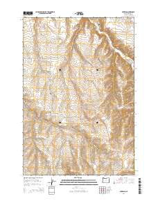
2014 Map of Mikkalo
USGS Topo · Published 2014About this map
The high plateau of Gilliam County is defined by deep drainages and isolated agricultural outposts in this 2014 survey. Small settlements like Mikkalo and Clem anchor the landscape, while the John Day Hwy follows the winding contours of the terrain. The map reveals the intricate network of canyons that carve through the region, including French Charlie Canyon and Juniper Canyon, which descend toward the water of Rock Cr. Genealogy interests are well-served by the inclusion of local burial sites like the Olex Cem and Clem Cem, providing specific locations for family history research in this sparse corner of Oregon. Transport through the canyon lands is highlighted by landmarks such as the Taylor Bridge, illustrating how infrastructure adapts to the rugged natural geometry of the Cow Canyon area.
Find a feature on this map
21 named features on this map. Tap any name to fly to it.
Don’t see what you’re looking for? This feature index may not catch every label — zoom into the map to look around manually.
Map Details
Editions of this 2014 Mikkalo Map
This is the sole edition of this map. No revisions or reprints were ever made.
Other maps of this area

1916 · Arlington
USGS Topo · 1:125,000

1916 · Condon
USGS Topo · 1:125,000

1953 · The Dalles
USGS Topo · 1:250,000

1956 · The Dalles
USGS Topo · 1:250,000

1957 · The Dalles
USGS Topo · 1:250,000

1964 · Turner Butte
USGS Topo · 1:24,000

1964 · Shutler Flat
USGS Topo · 1:24,000

1964 · Hickland Butte
USGS Topo · 1:24,000

1970 · Devils Backbone
USGS Topo · 1:24,000
1970 · Wolf Hollow Falls
USGS Topo · 1:24,000