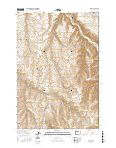
2017 Map of Mikkalo
USGS Topo · Published 2017About this map
Mikkalo and Clem anchor this high-desert plateau in Gilliam County, where agricultural life is shaped by the deep drainage of Rock Cr. The map reveals a landscape defined by sharp topographical changes, with a network of steep canyons such as French Charlie Canyon and Juniper Canyon cutting through the high country. For those tracing family histories in this part of Oregon, the map provides precise locations for the Olex Cem and Clem Cem, standing as silent markers of early ranching and farming communities. The road system, including Pennington Rd and Clem-Mikkalo Rd, follows the natural contours of the terrain, connecting isolated homesteads to larger features like Taylor Bridge and the expansive Pats Canyon. This 2017 survey reflects the enduring character of a rural region where land management and geography remain inextricably linked.
Find a feature on this map
23 named features on this map. Tap any name to fly to it.
Don’t see what you’re looking for? This feature index may not catch every label — zoom into the map to look around manually.
Map Details
Editions of this 2017 Mikkalo Map
This is the sole edition of this map. No revisions or reprints were ever made.
Other maps of this area

1916 · Arlington
USGS Topo · 1:125,000

1916 · Condon
USGS Topo · 1:125,000

1953 · The Dalles
USGS Topo · 1:250,000

1956 · The Dalles
USGS Topo · 1:250,000

1957 · The Dalles
USGS Topo · 1:250,000

1964 · Turner Butte
USGS Topo · 1:24,000

1964 · Shutler Flat
USGS Topo · 1:24,000

1964 · Hickland Butte
USGS Topo · 1:24,000

1970 · Devils Backbone
USGS Topo · 1:24,000
1970 · Wolf Hollow Falls
USGS Topo · 1:24,000