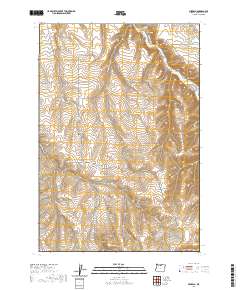
2020 Map of Mikkalo
USGS Topo · Published 2020About this map
Mikkalo and Olex anchor this portion of the Columbia Plateau, where the landscape is defined by the deeply incised drainage of Rock Cr. The map reveals a remote ranching and dryland farming environment marked by numerous canyons and hollows, including Cow Canyon, Pats Canyon, and the sprawling Juniper Canyon to the south. Small, isolated rural hubs are evidenced by the presence of the Olex Cem and Clem Cem, providing vital clues for family historians tracking the early inhabitants of this part of Gilliam County.
Find a feature on this map
24 named features on this map. Tap any name to fly to it.
Don’t see what you’re looking for? This feature index may not catch every label — zoom into the map to look around manually.
Map Details
Editions of this 2020 Mikkalo Map
This is the sole edition of this map. No revisions or reprints were ever made.
Other maps of this area

1916 · Arlington
USGS Topo · 1:125,000

1916 · Condon
USGS Topo · 1:125,000

1953 · The Dalles
USGS Topo · 1:250,000

1956 · The Dalles
USGS Topo · 1:250,000

1957 · The Dalles
USGS Topo · 1:250,000

1964 · Turner Butte
USGS Topo · 1:24,000

1964 · Shutler Flat
USGS Topo · 1:24,000

1964 · Hickland Butte
USGS Topo · 1:24,000

1970 · Devils Backbone
USGS Topo · 1:24,000
1970 · Wolf Hollow Falls
USGS Topo · 1:24,000