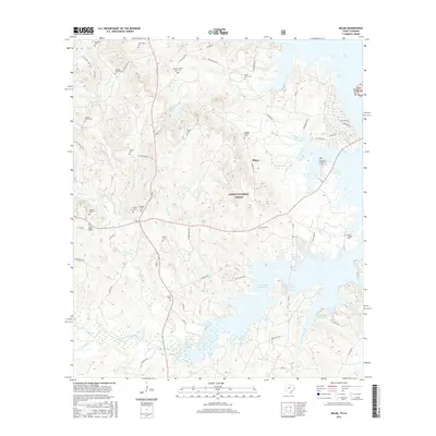
2016 Map of Milam
USGS Topo · Published 2016About this map
Milam serves as a central hub for this corner of East Texas, where the deep pine woods of the Sabine National Forest meet the sprawling fingers of the Toledo Bend Reservoir. The landscape is defined by its complex hydrology, with numerous drainages like Palo Gaucho Bayou, Wilson Br, and Corsey Cr feeding into the reservoir's western reaches. This area is exceptionally dense with family burial grounds, suggesting a long history of local settlement and genealogical significance. Names like the Gellatly Family Cem, Cooper-Harris Cem, and Evans Family Cem are scattered across the terrain. These sites, along with the Oliphant Memorial Cem and Cannon Family Cem, provide specific points of interest for those tracing heritage in Sabine County. The terrain is a mixture of forested uplands and the submerged lowlands of the reservoir, crossed by a network of local routes such as Lick Skillet Rd and W Carters Ferry Rd.
Find a feature on this map
69 named features on this map. Tap any name to fly to it.
Don’t see what you’re looking for? This feature index may not catch every label — zoom into the map to look around manually.
Map Details
Editions of this 2016 Milam Map
This is the sole edition of this map. No revisions or reprints were ever made.
Other maps of this area

1941 · Zwolle
USGS Topo · 1:62,500

1944 · Negreet
USGS Topo · 1:62,500

1944 · Patroon
USGS Topo · 1:62,500

1944 · Zwolle
USGS Topo · 1:62,500

1953 · Alexandria
USGS Topo · 1:250,000

1954 · Columbus
USGS Topo · 1:24,000

1954 · Negreet
USGS Topo · 1:62,500

1954 · Salter Creek
USGS Topo · 1:24,000

1955 · Alexandria
USGS Topo · 1:250,000

1956 · Patroon
USGS Topo · 1:62,500