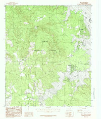
1984 Map of Milam
USGS Topo · Published 1984About this map
Sabine National Forest dominates this East Texas landscape, where the wooded terrain meets the expansive waters of the Toledo Bend Reservoir along the Louisiana border. The mid-1980s geography shows a mix of timberland and emerging lakeside developments. Settlements like Milam and Mid Lake Village serve as anchors in a region defined by its hydrology, with numerous drainages such as Mason Creek, Sulphur Creek, and Palo Gaucho Bayou carving through the forest toward the reservoir.
Find a feature on this map
30 named features on this map. Tap any name to fly to it.
Don’t see what you’re looking for? This feature index may not catch every label — zoom into the map to look around manually.
Map Details
Editions of this 1984 Milam Map
This is the sole edition of this map. No revisions or reprints were ever made.
Other maps of this area

1941 · Zwolle
USGS Topo · 1:62,500

1944 · Negreet
USGS Topo · 1:62,500

1944 · Patroon
USGS Topo · 1:62,500

1944 · Zwolle
USGS Topo · 1:62,500

1953 · Alexandria
USGS Topo · 1:250,000

1954 · Columbus
USGS Topo · 1:24,000

1954 · Negreet
USGS Topo · 1:62,500

1954 · Salter Creek
USGS Topo · 1:24,000

1955 · Alexandria
USGS Topo · 1:250,000

1956 · Patroon
USGS Topo · 1:62,500