
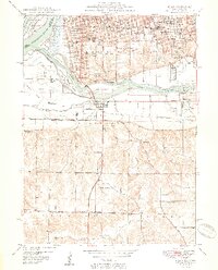
1950 Map of Milan
USGS Topo · Published 1950About this map
Rock Island and Moline anchor this post-war landscape where the confluence of the Mississippi River and the Rock River creates a complex network of islands and industrial corridors. The riverfront is defined by significant landmarks including the Filtration Plant and Davenport Harbor, while the interior shows the density of the mid-century Tri-Cities expansion. The map details a heavy concentration of local institutions, from the Rock Island High Sch and Junior High Sch to numerous neighborhood greenspaces like Long View Park and Black Hawk State Park.
Find a feature on this map
79 named features on this map. Tap any name to fly to it.
Don’t see what you’re looking for? This feature index may not catch every label — zoom into the map to look around manually.
Map Details
Editions of this 1950 Milan Map
2 editions found
Other maps of this area

1891 · Davenport
USGS Topo · 1:62,500

1892 · Leclaire
USGS Topo · 1:62,500

1893 · Leclaire
USGS Topo · 1:62,500

1894 · Davenport
USGS Topo · 1:62,500

1899 · Clinton
USGS Topo · 1:125,000

1901 · Rock Island
USGS Topo · 1:125,000

1910 · Rock Island
USGS Topo · 1:125,000

1912 · Milan
USGS Topo · 1:62,500

1937 · Orion
USGS Topo · 1:62,500

1944 · Milan
USGS Topo · 1:62,500