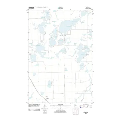
2010 Map of Mildred
USGS Topo · Published 2010About this map
Mildred serves as the primary settlement hub in this lake-heavy portion of Cass County, situated near the Pine River Cemetery and the northern reaches of the Paul Bunyan Trl. The landscape is dominated by a dense network of water bodies, notably Big Portage Lake, Lake Hattie, and Clear Lake, many of which are managed by structures like the Portage Lake Dam and Hattie Lake Dam. The abundance of water defines the local economy and geography, supported by recreational sites such as the Tuck-A-Way Resort and Campground and Lindsey Lake Campgrounds. The winding course of the Pine River ties these basins together, illustrating a classic Northwoods drainage pattern where roads like County Hwy 42 and Mildred Chapel Rd provide the primary access through the wooded lakefront terrain.
Find a feature on this map
80 named features on this map. Tap any name to fly to it.
Don’t see what you’re looking for? This feature index may not catch every label — zoom into the map to look around manually.
Map Details
Editions of this 2010 Mildred Map
This is the sole edition of this map. No revisions or reprints were ever made.
Other maps of this area

1919 · Leader
USGS Topo · 1:62,500

1953 · Brainerd
USGS Topo · 1:250,000

1957 · Brainerd
USGS Topo · 1:250,000

1958 · Brainerd
USGS Topo · 1:250,000

1959 · Pine River
USGS Topo · 1:24,000

1959 · Jenkins
USGS Topo · 1:24,000

1965 · Brainerd
USGS Topo · 1:250,000

1970 · Backus
USGS Topo · 1:24,000

1970 · Hackensack
USGS Topo · 1:24,000
1970 · Bungo Creek
USGS Topo · 1:24,000