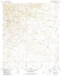
1979 Map of Mildred Peak
USGS Topo · Published 1979About this map
The Baboquivari Mountains dominate the western edge of this 1970s landscape, bordering the Papago Indian Reservation. The map details a high-desert environment where life is organized around intermittent water sources and ranching outposts. Cattle operations are evident at the Santa Margarita Ranch, Shaffer Camp, and Las Moras Ranch, supported by a sophisticated network of infrastructure including the Cemetery Tank, Mitchell Tank, and numerous windmills and wells.
Find a feature on this map
54 named features on this map. Tap any name to fly to it.
Don’t see what you’re looking for? This feature index may not catch every label — zoom into the map to look around manually.
Map Details
Editions of this 1979 Mildred Peak Map
3 editions found
Other maps of this area

1920 · Arivaca
USGS Topo · 1:125,000

1940 · Palo Alto Ranch
USGS Topo · 1:62,500

1941 · Presumido Peak
USGS Topo · 1:62,500

1941 · Baboquivari Peak
USGS Topo · 1:62,500

1941 · Arivaca
USGS Topo · 1:62,500

1943 · Fresnal
USGS Topo · 1:125,000

1943 · Arivaca
USGS Topo · 1:62,500

1943 · Palo Alto Ranch
USGS Topo · 1:62,500

1943 · Presumido Peak
USGS Topo · 1:62,500

1944 · Baboquivari Peak
USGS Topo · 1:62,500