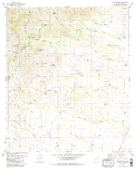
1979 Map of Mildred Peak
USGS Topo · Published 1979About this map
The Baboquivari Mountains dominate this 1970s landscape, where a network of desert washes and isolated ranching outposts define the character of Pima County. Part of the Indian Reservation Papago, the area shows a history of mineral extraction at the Gold Bullion Mine and Jupiter Mine, while cattle ranching is evidenced by the presence of the Santa Margarita Ranch, Las Moras Ranch, and Shaffer Camp. The terrain is marked by significant peaks such as Mildred Peak and Osobavi Peak, with complex drainage patterns across Thomas Canyon Wash and Las Moras Wash. Genealogists and local historians can find specific points of interest like the Cem near Cemetery Tank, and named water sources such as Charlie Bent Well and Clemente Windmill, which were essential for survival in this arid environment.
Find a feature on this map
57 named features on this map. Tap any name to fly to it.
Don’t see what you’re looking for? This feature index may not catch every label — zoom into the map to look around manually.
Map Details
Editions of this 1979 Mildred Peak Map
3 editions found
Other maps of this area

1920 · Arivaca
USGS Topo · 1:125,000

1940 · Palo Alto Ranch
USGS Topo · 1:62,500

1941 · Presumido Peak
USGS Topo · 1:62,500

1941 · Baboquivari Peak
USGS Topo · 1:62,500

1941 · Arivaca
USGS Topo · 1:62,500

1943 · Fresnal
USGS Topo · 1:125,000

1943 · Arivaca
USGS Topo · 1:62,500

1943 · Palo Alto Ranch
USGS Topo · 1:62,500

1943 · Presumido Peak
USGS Topo · 1:62,500

1944 · Baboquivari Peak
USGS Topo · 1:62,500