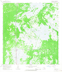
1959 Map of Miles City
USGS Topo · Published 1968About this map
The settlement of Miles City sits at a critical junction of infrastructure and wilderness in this late-1950s survey of the Florida Everglades. Dominated by the Atlantic Coast Line railroad and the Miles City Lookout Tower, the area reveals a landscape defined by water and slightly elevated hammocks. The map meticulously records numerous archaeological sites, including a prominent Indian Mound in the northwest and the East Hinson Indian Mounds to the east, suggesting long-standing human presence in this swampy environment. Expansive wetland systems like the Okaloacoochee Slough and East Hinson Marsh are punctuated by named high points such as Hog Island, Platt Island, and Lone Chickee Island. The presence of an Old Railroad Grade and the East Hinson Grade trace the history of regional transport and resource extraction through the Fakahatchee Strand and Miles City Prairie before modern drainage and development altered these traditional corridors.
Find a feature on this map
30 named features on this map. Tap any name to fly to it.
Don’t see what you’re looking for? This feature index may not catch every label — zoom into the map to look around manually.
Map Details
Editions of this 1959 Miles City Map
4 editions found
Other maps of this area

1956 · West Palm Beach
USGS Topo · 1:250,000

1957 · West Palm Beach
USGS Topo · 1:250,000

1958 · West Palm Beach
USGS Topo · 1:250,000

1958 · Catherine Island
USGS Topo · 1:24,000

1958 · Sunniland
USGS Topo · 1:24,000

1958 · Immokalee SW
USGS Topo · 1:24,000

1959 · Miles City
USGS Topo · 1:24,000

1959 · Deep Lake
USGS Topo · 1:24,000

1959 · Deep Lake SW
USGS Topo · 1:24,000
1962 · Catherine Island
USGS Topo · 1:24,000