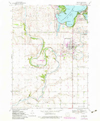
1970 Map of Milford
USGS Topo · Published 1983About this map
West Okoboji Lake defines the northern landscape of this survey, surrounded by established recreation and settlement areas like Wahpeton and Arnolds Park. The map documents a transition from the dense lakeside activity at Gull Point State Park to the agricultural expanses of Lake Ville and Milford townships. The city of Milford serves as a central hub, with the nearby Old Town and local landmarks like St Josephs Cem providing specific points of interest for genealogical research.
Find a feature on this map
43 named features on this map. Tap any name to fly to it.
Don’t see what you’re looking for? This feature index may not catch every label — zoom into the map to look around manually.
Map Details
Editions of this 1970 Milford Map
2 editions found
Other maps of this area

1954 · Fairmont
USGS Topo · 1:250,000

1958 · Fairmont
USGS Topo · 1:250,000

1966 · Spencer
USGS Topo · 1:24,000

1966 · Dickens
USGS Topo · 1:24,000

1970 · Milford
USGS Topo · 1:24,000

1970 · Everly
USGS Topo · 1:24,000

1970 · Okoboji
USGS Topo · 1:24,000

1970 · Spirit Lake SE
USGS Topo · 1:24,000

1970 · Lake Park SE
USGS Topo · 1:24,000

1970 · Spirit Lake
USGS Topo · 1:24,000