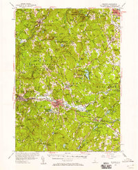
1953 Map of Milford
USGS Topo · Published 1958About this map
The Souhegan River and the Boston and Maine railroad corridor define the industrial and residential heart of this mid-century New Hampshire landscape. Centered on Milford and Amherst, the map reveals a post-war transition where traditional mill towns and small farms are increasingly interspersed with institutional and recreational lands. The presence of the U S Military Reservation Air Force Bombing Range near Joe English Hill contrasts sharply with the quietude of Baboosic Lake and Curtis Dogwood State Pk.
Find a feature on this map
148 named features on this map. Tap any name to fly to it.
Don’t see what you’re looking for? This feature index may not catch every label — zoom into the map to look around manually.
Map Details
Editions of this 1953 Milford Map
3 editions found
Other maps of this area

1886 · Lowell
USGS Topo · 1:62,500

1887 · Fitchburg
USGS Topo · 1:62,500

1889 · Fitchburg
USGS Topo · 1:62,500

1893 · Lowell
USGS Topo · 1:62,500

1893 · Fitchburg
USGS Topo · 1:62,500

1893 · Groton
USGS Topo · 1:62,500

1900 · Peterboro
USGS Topo · 1:62,500

1905 · Manchester
USGS Topo · 1:62,500

1906 · Milford
USGS Topo · 1:62,500

1918 · Lowell
USGS Topo · 1:62,500